HEProOE: Hyperedge-Enhanced Spatial Community Detection Method
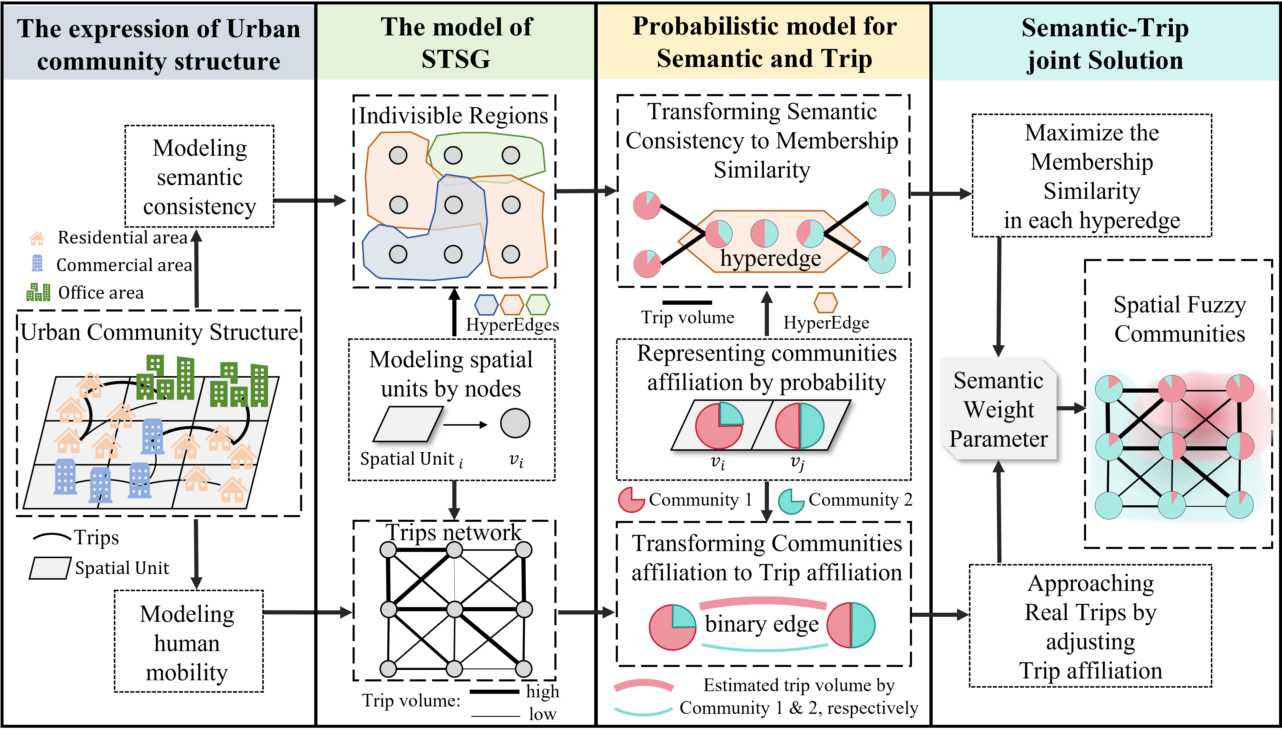
Building upon our previous work with ProOE, we are thrilled to introduce the Hyperedge-Enhanced Probabilistic Optimal Estimation (HEProOE) method. This advanced model addresses a key limitation in mobility-based community detection: the fragmentation of large, semantically consistent areas. HEProOE integrates hyperedges to represent these “Indivisible Regions” (IRs), ensuring that the detected communities are not only structurally sound but also functionally coherent.
- Paper: HEProOE: A hyperedge enhanced probabilistic optimal estimation method for detecting spatial fuzzy communities.
- GitHub Repository: The data and code can be requested from me.
Abstract
Identifying spatial communities with human mobility data has emerged as a key approach to understanding urban spatial structure. However, relying solely on human mobility data to partition spatial communities ignores the semantic information and may fragment large, semantic consistent Indivisible Regions (IRs) such as college campuses. Furthermore, individual spatial units often belong simultaneously to multiple IRs, creating membership uncertainty, while the spatial stochasticity of human movements inherently introduces ambiguity to the boundaries of spatial fuzzy communities. To address these challenges, we proposed the Hyperedge-Enhanced Probabilistic Optimal Estimation method (HEProOE) that integrated the hyperedge into spatial fuzzy community detection, representing IRs as semantic consistent regions. First, IRs were represented as hyperedges, where each spatial unit holds a probabilistic community membership. Second, a novel distance-weighted Jensen-Shannon (JS) divergence metric was introduced to measure the semantic consistency within each hyperedge. Finally, this metric was converted into a new likelihood component and seamlessly integrated with the mobility-based ProOE model, yielding a unified framework that simultaneously optimizes for both mobility patterns and semantic consistency. Experimental results demonstrated that HEProOE uncovers spatial fuzzy communities with significantly higher semantic consistency, providing an effective tool for a more authentic understanding of urban spatial structures.
The Challenge: Beyond Mobility Patterns
While models like ProOE excel at identifying fuzzy communities from mobility data, they can sometimes break apart functionally unified areas—like a large university campus or a financial district—because the internal mobility patterns might not be perfectly uniform. These Indivisible Regions (IRs) have a strong semantic identity that should be preserved.
The HEProOE Framework: Integrating Semantics with Hyperedges
HEProOE solves this by introducing hyperedges. In network science, a regular edge connects two nodes. A hyperedge can connect multiple nodes at once. We use hyperedges to model IRs, grouping all spatial units within a single functional zone (e.g., all the zones that make up “Midtown”).
This creates a unified probabilistic framework that balances two goals:
- Aligning with observed mobility patterns (the strength of ProOE).
- Enforcing semantic consistency within known IRs (the new enhancement).
The overall methodology is illustrated below.
Study Area and Data
We again use New York City as our study area. The IRs (hyperedges) were sourced from OpenStreetMap, selecting 18 prominent, named regions like “Upper West Side” and “Lenox Hill.” The mobility data comes from over 8 million taxi trips.
![Figure 2. Overview of study area and data. (a) Overview of the research area. (b) Trip data for New York City. (c) IRs obtained from OpenStreetMap [Data © OpenStreetMap contributors; licensed under ODbL 1.0; openstreetmap.org/copyright].](/2025/11/17/HEProOE/Figure2.png)
Key Results: Semantically Consistent Communities
The integration of hyperedges leads to a significant improvement in the quality and interpretability of the detected communities.
Visual Comparison: ProOE vs. HEProOE
The figure below shows a direct comparison between the communities detected by the original ProOE and the new HEProOE. While ProOE identifies a reasonable structure, it incorrectly splits the well-defined “Upper West Side” and “Upper East Side” regions. HEProOE, guided by the semantic hyperedges, correctly preserves the integrity of these large functional zones.
Quantitative Evaluation
To provide a quantitative basis for our comparison, we measured the alignment between each model’s community partitions and the predefined Identified Regions (IRs) using Fuzzy Normalized Mutual Information (FNMI)30. The results are telling: HEProOE achieved the highest FNMI score (0.440), surpassing both ProOE (0.410) and Hypergraph-MT (0.312). This score confirms that our model’s partitions correspond most closely to the city’s established semantic geography, a finding corroborated by visual analysis.
By combining the strengths of probabilistic modeling with the structural integrity of hypergraphs, HEProOE provides a powerful and more authentic tool for understanding the complex fabric of our cities.